A UNIQUE PARTNERSHIP between the Camping and Caravanning Club and Ordnance Survey (OS) looks to make exploring easier than ever this season.
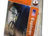
[tl:gallery size=460×704]OS is the national mapping agency for Great Britain, and one of the world’s largest producers of maps. It is working with the Club to generate bespoke maps, centred around Club and Camping in the Forest Sites.
The new OS Explorer (1:25 000 scale) and Landranger (1:50 000 scale) custom made maps allow anyone to customise a map, choose their own title and select an individual cover image from a wide selection or beautiful photographs.
Delighted to team up
Ruth Doyle, the Club’s Marketing & Communications Director, is delighted to team up with Ordnance Survey and said: “Our campers love walking, cycling and running when they stay on our sites and Ordnance Survey maps are an excellent way for them to discover a new area. With so many more people enjoying the great outdoors these days, we think everyone could get more out of their break using the most up-to-date mapping available, whether that’s paper or digital.”
OS’s Alastair Tinker is similarly excited, saying “I’m really excited by our new partnership. This is a great opportunity for both organisations to work together to help their customers get the most out of their outdoor experience”
For more details about the service, click here